-

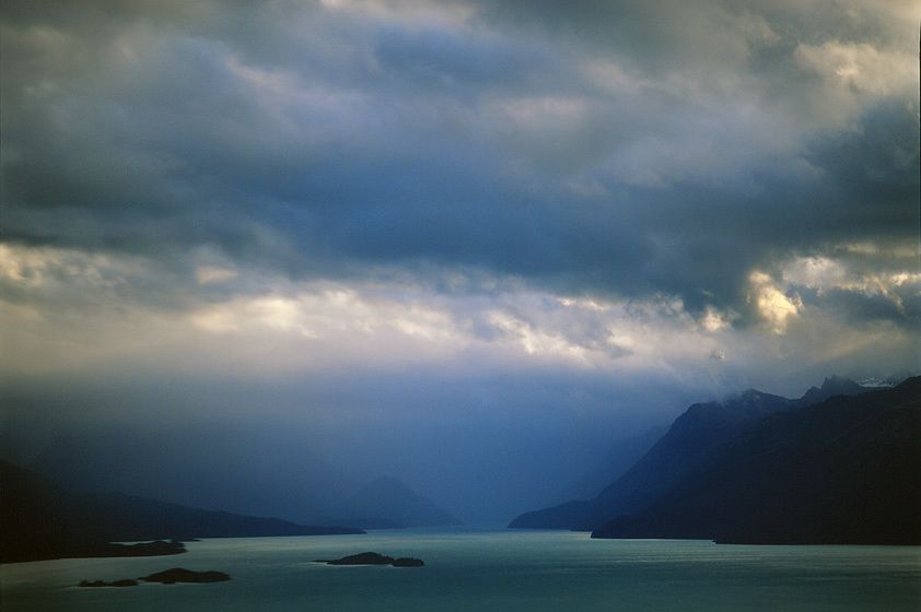
LAKE CLARK NATIONAL PARK
This is Lake Clark National Park which will SHARE A BORDER with the Pebble mine, proposed to be the largest copper/cyanide gold-leach mine ever built. Eventually there will be a toxic cyanide "lagoon" similar in size to what you see here, only lethal NOT productive.Should these kinds of American natural resources be squandered in the pursuit of fashionable jewelry?
-

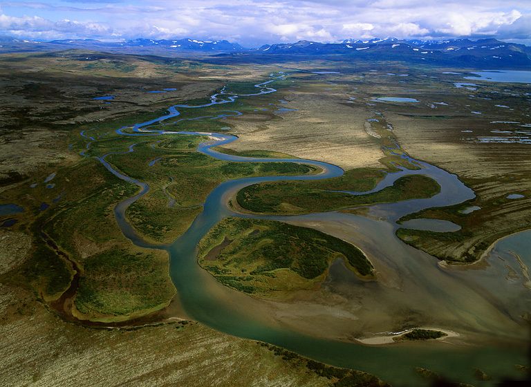
STUYAHOK RIVER SYSTEM, BRISTOL BAY HEADWATERS
NO PEBBLE MINE #5, Pictures from Ground Zero: SW Alaska/Bristol Bay is a world of water... water everywhere, and right at the surface. The fishery thrives in this world. The Pebble mine, proposed as the largest copper/cyanide gold-leach mine ever constructed has NO PLACE HERE! Keep American fisheries clean - say NO to The Pebble mine!
-
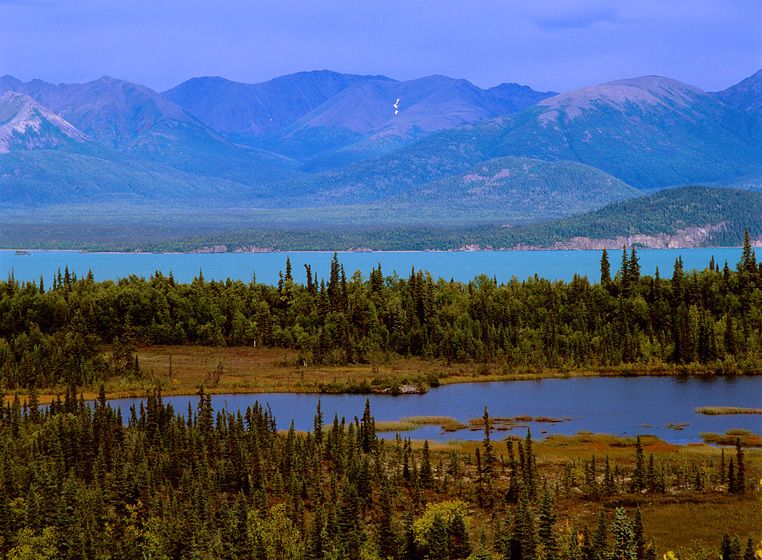
UPPER TALARIK CREEK, TUNDRA PONDS AND LAKE ILIAMNA
-

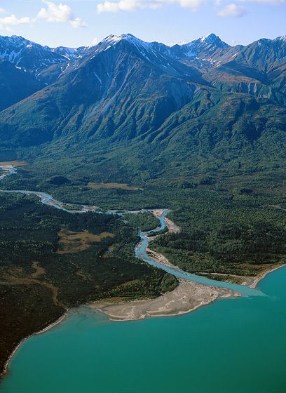
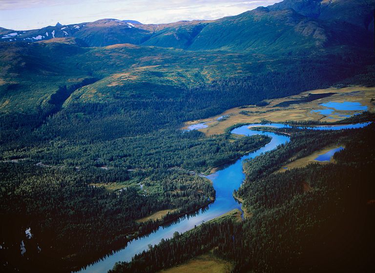
NEW HALEN RIVER CONNECTING LAKE CLARK TO LAKE ILIAMNA
The New Halen river flows between Lake Clark and Lake Iliamna, and offers some of the least tried Class 6 whitewater in North America. It will also have a bridge over it and a haul road next to supporting thousands of miles of industrial truck traffic if the Pebble mine is constructed.
-

LAKE ILIAMNA
The Pebble min will take more electricity to operate than Anchorage, the largest city in Alaska. The Pebble intends to generate power from burning coal mined on-site. Coupled with the industrial vehicle smog the mine will generate, you can kiss the air quality of Lake Iliamna, Lake Clark National Park, and Katmai National Park goodbye,..and good luck keeping the mercury from burning coal out of the fishery! Building The Pebble threatens American jobs and clean food resources – say NO!.
-

HUNDREDS OF RIVERS, THOUSANDS OF LAKES, MILLIONS OF FISH - NO PEBBLE MINE
NO PEBBLE MINE #8, Pictures from Ground Zero: The Pebble mine will be 2,000ft deep and 2-miles across. There will be a constant influx of groudwater that will require pumping 24/7/365 to keep the mine from flooding. That liquid, tainted with cyanide and iron oxides, will be pumped into "lagoons" that spread ovr 20-square-miles of the landscape. Birds on the Pacific flyway will see that, expecting this...
-

VOLCANIC FOOTHILLS, LAKE CLARK
NO PEBBLE MINE #14, Pictures from Ground Zero: SW Alaska and the Alaska Range host many volcanoes and are adjacent one of the most significant seismic zones in North America. The Pebble mine plans to store cyanide-toxic mine slurry in 20-SQUARE-MILES of plastic lined, lake-like pits supposedly contained IN PERPETUITY by a series of earthen dams larger than Three Gorges in China. HELLO !?!?!
-

TWIN LAKES, LAKE CLARK NATIONAL PARK
NO PEBBLE MINE #16, Pictures from Ground Zero: The state parks, national parks and wildlife refuges of southwest Alaska are the essence of wild land. These habitats are also the headwaters of the Bristol Bay salmon fisheries and the most diverse freshwater ecosystem in North America. Parks and fish are renewable resource job providers. THERE IS NO PLACE IN THIS ENVIRONMENT FOR THE TOXIC BY-PRODUCTS THAT WILL BE INTRODUCED BY THE PEBBLE MINE COMPLEX.
-

WATER, WATER EVERYWHERE!
NO PEBBLE MINE #17, Pictures from Ground Zero: Southwest Alaska is one of the cleanest and most diverse freshwater habitats left in North America. As clean water resources elsewhere are ruined by industrial consumption, fracking, and bad mining practice, perhaps we should prevent the PEBBLE MINE from "accidentally" impairing this huge clean water system. It is not JUST the fish, PURE water will be gold in the near future.
-
![MULCHATNA RIVER SYSTEM, BRISTOL BAY HEADWATER]()
MULCHATNA RIVER SYSTEM, BRISTOL BAY HEADWATER
-
![LAKE CLARK (background) NATIONAL PARK]()
LAKE CLARK (background) NATIONAL PARK
-
![EVERYBODY WANTS TO FISH TALARIK CREEK]()
EVERYBODY WANTS TO FISH TALARIK CREEK
-

WORLD CLASS FLYFISHING, UPPER TALARIK CREEK
Upper Tularik Creek is a world class fly-fishing destination. Recreational fishing/tourism in Southwest Alaska generates $millions of annual revenue and American employment IN PERPETUITY if well managed.The Pebble mine's life will be relatively short but it will generate millions of gallons of toxic, cyanide-leach solution which will have to be stored IN PERPETUITY to protect these waters and the connected American fishery.
-
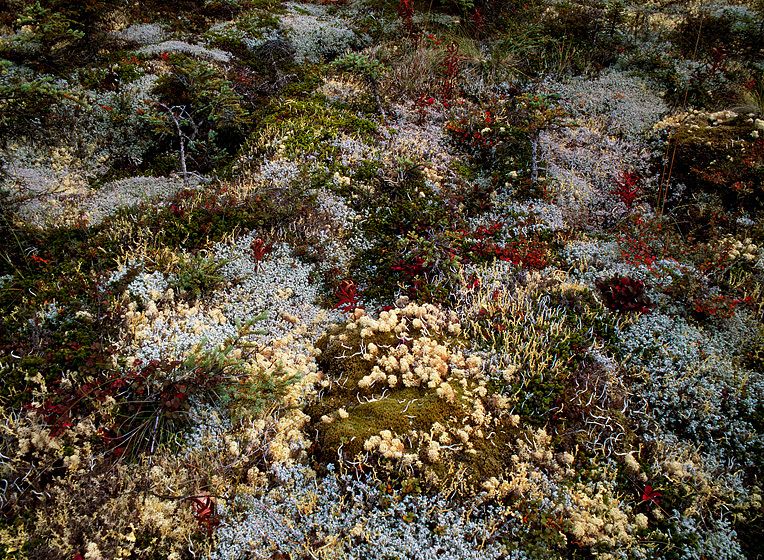
![TUNDRA CARPET - LOTS OF LIVING THINGS!]()
TUNDRA CARPET - LOTS OF LIVING THINGS!
-
![TRIBUTARY AT THE HEAD OF LAKE CLARK]()
TRIBUTARY AT THE HEAD OF LAKE CLARK
-

PEBBLE MINE SITE, 2007
PEBBLE MINE SITE, 200720” x 24” / $1,50024” x 30” / $2,25030” x 40” / $3,500The signed, limited edition of 33, includes all of the above sizes. Print will be shipped directly to client's framer.48" x 65" edition of 3Current price: $6,500
-
![GLACIAL STRIATIONS IN THE ROCK SUCCUMB TO NEW MARKINGS FROM THE RIVER]()
GLACIAL STRIATIONS IN THE ROCK SUCCUMB TO NEW MARKINGS FROM THE RIVER
-
![ILIAMNA RIVER WATERSHED]()
ILIAMNA RIVER WATERSHED
-

LAKE CLARK NATIONAL PARK
NO PEBBLE MINE #13, Pictures from Ground Zero: The Pebble Mine ore deposit is apparently part of an ancient volcano. Lava flows and volcanic debris have built much of the SW landscape. BENEATH THE POROUS STONE SURFACE, THE WATERS FLOW - sometimes literally THROUGH the rock layers. Many rivers and watersheds are "connected" in this way. Containing any spills from the 20-SQUARE-miles of cyanide slurry lagoons created by the Pebble Mine would be virtually impossible.
-
![WILD RIVERS, WILD HEALTHY FISH]()
WILD RIVERS, WILD HEALTHY FISH
-
 mine leaking / draining water downstream affects everything - follow the water in this picture (clue: it is where the life is).")
UPPER TALARIK WATERSHED, BRISTOL BAY HEADWATERS
NO PEBBLE MINE #9, Pictures from Ground Zero: The EPA has determined the Pebble Mine will damage salmon rivers, destroy salmon habitat, and is a threat to the Bristol Bay fishery... THANK YOU!!!! This IS Ground Zero and you can see why a toxic (cyanide) mine leaking / draining water downstream affects everything - follow the water in this picture (clue: it is where the life is).
-

BLOWING AGAINST THE WIND
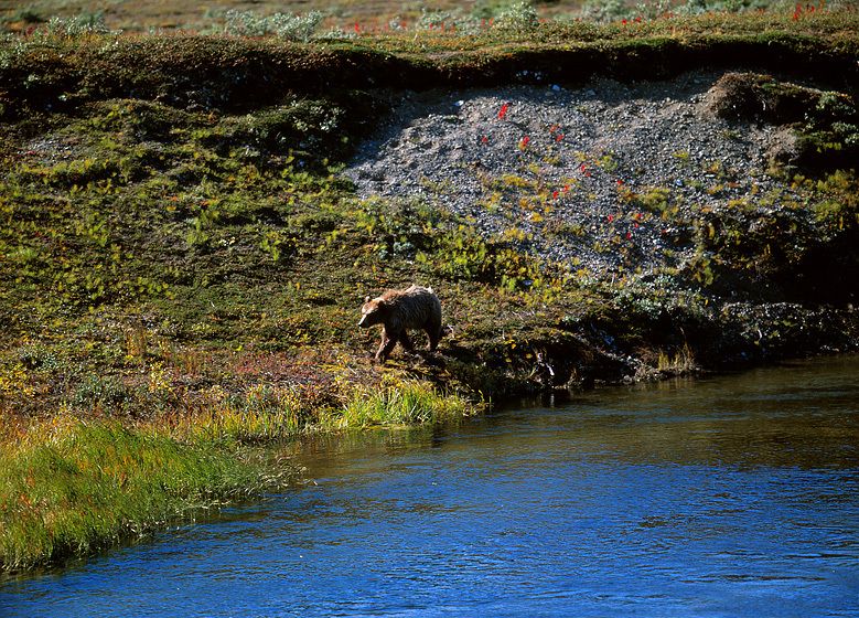
NO PEBBLE MINE #15, Pictures from Ground Zero: Bristol Bay, the most productive commercial salmon fishery in the history of the world is not the only renewable resource at risk if the Pebble Mine is developed. This industrial mega-development will impact, 2 national parks, 3 national wildlife refuges, and 4 state-designated sanctuaries - home not just to fish, but bear, moose, caribou, wolf, walrus, marten, fox, eagle and 1000's of migratory birds.
-
. GOOD LUCK KEEPING SUCH A ROAD OPEN IN THE WINTER! Will American taxpayers be deluded into subsidizing this road as they were for all the timber extraction roads in the Tongass rainforest?")
LAKE CLARK, STORMING
NO PEBBLE MINE #10, Pictures from Ground Zero: If constructed The Pebble will be the largest open-pit mine ever built, but beyond the mine site a "haul" road system must also be carved through the 10-17,000 ft Alaska Range to reach a port in Cook Inlet (also to be built as part of the complex). GOOD LUCK KEEPING SUCH A ROAD OPEN IN THE WINTER! Will American taxpayers be deluded into subsidizing this road as they were for all the timber extraction roads in the Tongass rainforest?
-

TWIN LAKES, LAKE CLARK NATIONAL PARK
NO PEBBLE MINE #7, Pictures from Ground Zero: This is Twin Lakes in Lake Clark National Park. Beyond the distant mountains to the right, the proposed Pebble mine complex wld be belching industrial auto smog, AND a mercury-laden haze from coal-fired power generation. Their 20-SQUARE-MILE cyanide-slurry lagoon wld seem ocean-like from shore-to-shore. How can foreigncorporations be allowed do this to American resources?
-
 a clean American food and job resource. Don't allow southwest Alaska to be trashed by international industrial development.")
A GOOD DAY FOR FLOATING
NO PEBBLE MINE #11, Pictures from Ground Zero: Oil still oozes from shoreline sand in Prince William Sound. Oil and other toxins saturate the Gulf Coast. Cyanide and acidic iron oxides should NEVER BE INTRODUCED into the Bristol Bay environment. Say NO TO THE PEBBLE MINE and keep the greatest wild salmon fishery in the world (also herring, halibut, etc.) a clean American food and job resource. Don't allow southwest Alaska to be trashed by international industrial development.
-
![BIG WEATHER FUNNELS THROUGH LAKE CLARK AND THE ALASKA RANGE]()
BIG WEATHER FUNNELS THROUGH LAKE CLARK AND THE ALASKA RANGE
-

TUNDRA AND SPRUCE
NO PEBBLE MINE #6, Pictures from Ground Zero: Besides a massive complex of roads that will define the Pebble mine extraction site, a long "haul" road must be built to get minerals out. The haul road will bridge the New Halen River coming out of Lake Clark National Park; it will run adjacent the shoreline of Lake Iliamna for miles bridging/disrupting dozens of salmon streams and possibly the unique species of freshwater seal that lives in the lake.
-

LAKE ILIAMNA
NO PEBBLE MINE #12, Pictures from Ground Zero: This is Lake Iliamna, one of the largest freshwater lakes in the world and home to a unique species of freshwater seal found nowhere else. Iliamna is also the headwater of the massive Kvichak river, the most productive commercial salmon river in all of Southwest AK. ASTOUNDINGLY, THE NEARBY PEBBLE MINE WILL PRODUCE 3,000lbs OF TOXIC TAILINGS FOR EVERY MAN, WOMAN, AND CHILD LIVING ON THE PLANET TODAY, and to neutralize these acid producing tailings, the mine developers have suggested dumping the them in the lake.
-
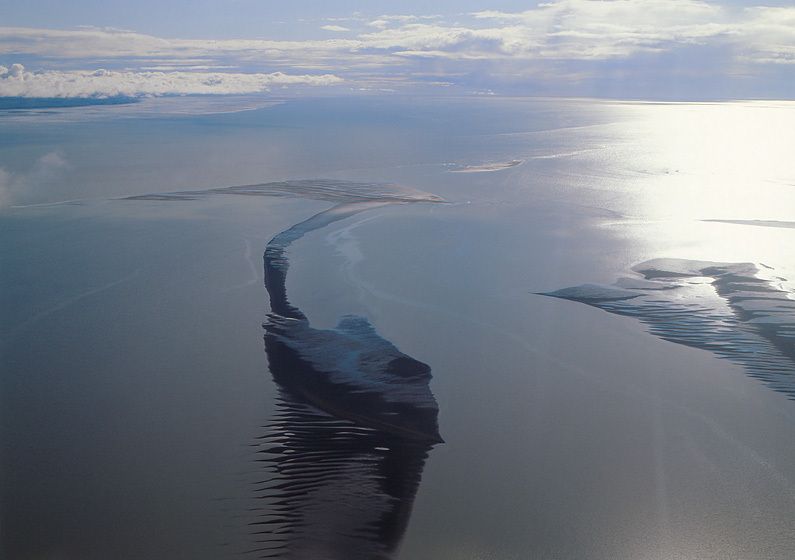
![DEADMAN SANDS EMERGE AS TIDE DROPS, KVICHAK RIVER MOUTH AT BRISTOL BAY]()
DEADMAN SANDS EMERGE AS TIDE DROPS, KVICHAK RIVER MOUTH AT BRISTOL BAY


 mine leaking / draining water downstream affects everything - follow the water in this picture (clue: it is where the life is).")

. GOOD LUCK KEEPING SUCH A ROAD OPEN IN THE WINTER! Will American taxpayers be deluded into subsidizing this road as they were for all the timber extraction roads in the Tongass rainforest?")

 a clean American food and job resource. Don't allow southwest Alaska to be trashed by international industrial development.")